Search
[{{{type}}}] {{{reason}}}
{{/data.error.root_cause}}{{{_source.title}}} {{#_source.showPrice}} {{{_source.displayPrice}}} {{/_source.showPrice}}
{{#_source.showLink}} {{/_source.showLink}} {{#_source.showDate}}{{{_source.displayDate}}}
{{/_source.showDate}}{{{_source.description}}}
{{#_source.additionalInfo}}{{#_source.additionalFields}} {{#title}} {{{label}}}: {{{title}}} {{/title}} {{/_source.additionalFields}}
{{/_source.additionalInfo}}Latest News
Subscribe to the Update
- Category: Front Page News
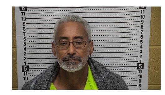
 Jerry Amador
Courtesy of the Hurley Police Department
Last night, 65-year-old Jerry Amador, a resident from North Hurley found himself in a bit of trouble after a series of reckless decisions. The Hurley Police Department attempted to pull him over for speeding, but instead of stopping, Mr. Amador decided to lead officers on a high-speed chase.
The pursuit ended at his home, where he attempted to flee on foot but was quickly apprehended by law enforcement. It was later revealed that Mr. Amador has a troubling history, with nearly 30 years of drunk driving offenses.
- Category: Front Page News
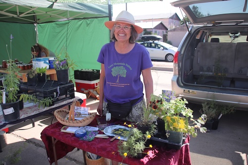
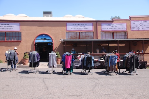
Photos by Mary Alice Murphy
On a not too busy Saturday in Silver City, Trish Hurley was selling her native plants at the Farmers' Market and Morningstar was having a parking lot sale, with some reduced prices inside, too.


- Category: Front Page News
Silver City, NM, Aug. 11, 2025 — Effective Monday, August 11, 2025, at 7:00 a.m., the ad hoc Type 3 Incident Management Team (IMT) under Incident Commander Dustin Roper transferred command of the Daisy Fire to a Type 4 Organization from the Gila National Forest. This will be the final news release. The Daisy Fire remains at 46 acres with an increase in containment to 80%.
Over the weekend, the Gila Interagency Hotshot Crew and the Mimbres New Mexico State Forestry Crew achieved the objectives set by the IMT for full suppression. With handline construction completed, firefighters hiked out ahead of incoming storms on Saturday afternoon.
- Category: Front Page News
Fort Bayard celebrates its 159th birthday 0080225
Photos and article by Mary Alice Murphy
The First Bayard Historic Preservation Society hosted the birthday celebration at the New Deal Theater, with a speaker, John Baker, an FBHPS and volunteer firefighter, talking about the history of firefighting at Fort Bayard.
- Category: Weather
 Southwest Desert/Lower Gila River Valley NM-
Upper Gila River Valley NM-
Southern Gila Region Highlands/Black Range NM-
254 PM MDT Sun Aug 10 2025
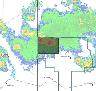
...A STRONG THUNDERSTORM WILL IMPACT NORTHWESTERN GRANT COUNTY THROUGH 400 PM MDT...
At 253 PM MDT, Doppler radar was tracking several strong
thunderstorms in northwest Grant county, moving southeast at 20 mph.
HAZARD...Wind gusts up to 50 mph and half inch hail.
SOURCE...Radar indicated.
- Category: Front Page News
USFS has informed Grant County that the Gila National Forest (GNF) fire danger rating has moved down from very high to high.
As an FYI, the GNF moved up to high on 9/30/24 and has remained at that level and higher (very high and extreme) since then.
Page 70 of 155
Content on the Beat
WARNING: All articles and photos with a byline or photo credit are copyrighted to the author or photographer. You may not use any information found within the articles without asking permission AND giving attribution to the source. Photos can be requested and may incur a nominal fee for use personally or commercially.
Disclaimer: If you find errors in articles not written by the Beat team but sent to us from other content providers, please contact the writer, not the Beat. For example, obituaries are always provided by the funeral home or a family member. We can fix errors, but please give details on where the error is so we can find it. News releases from government and non-profit entities are posted generally without change, except for legal notices, which incur a small charge.
NOTE: If an article does not have a byline, it was written by someone not affiliated with the Beat and then sent to the Beat for posting.
Images: We have received complaints about large images blocking parts of other articles. If you encounter this problem, click on the title of the article you want to read and it will take you to that article's page, which shows only that article without any intruders.
New Columnists: The Beat continues to bring you new columnists. And check out the old faithfuls who continue to provide content.
Newsletter: If you opt in to the Join GCB Three Times Weekly Updates option above this to the right, you will be subscribed to email notifications with links to recently posted articles.
Editor's Notes
It has come to this editor's attention that people are sending information to the Grant County Beat Facebook page. Please be aware that the editor does not regularly monitor the page. If you have items you want to send to the editor, please send them to editor@grantcountybeat.com. Thanks!
Here for YOU: Consider the Beat your DAILY newspaper for up-to-date information about Grant County. It's at your fingertips! One Click to Local News. Thanks for your support for and your readership of Grant County's online news source—www.grantcountybeat.com
Feel free to notify editor@grantcountybeat.com if you notice any technical problems on the site. Your convenience is my desire for the Beat. The Beat totally appreciates its readers and subscribers!
Compliance: Because you are an esteemed member of The Grant County Beat readership, be assured that we at the Beat continue to do everything we can to be in full compliance with GDPR and pertinent US law, so that the information you have chosen to give to us cannot be compromised.
Submitting to the Beat
Those new to providing news releases to the Beat are asked to please check out submission guidelines at https://www.grantcountybeat.com/about/submissions. They are for your information to make life easier on the readers, as well as for the editor.
Advertising: Don't forget to tell advertisers that you saw their ads on the Beat.
Classifieds: We have changed Classifieds to a simpler option. Check periodically to see if any new ones have popped up. Send your information to editor@grantcountybeat.com and we will post it as soon as we can. Instructions and prices are on the page.


